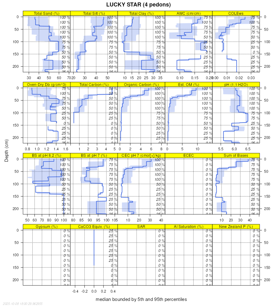
| Lucky Star, very stony surface-Alpon family-Lucky Star, very stony surface, moist, complex, 10 to 28 percent slopes | 1002 | 7230 | 2899432 | 2w1fm | id713 | | 1:24000 |
Lucky Star-Broad Canyon-Broad Canyon family, complex, 5 to 30 percent slopes, extremely bouldery surface | 1044 | 6291 | 2980832 | 2wzzt | id713 | | 1:24000 |
Coldfeet-Lucky Star complex, 15 to 35 percent slopes, very stony surface | 1056 | 4368 | 2980842 | 2x004 | id713 | | 1:24000 |
Houlihan family-Broad Canyon, very stony surface-Lucky Star family, very stony surface, complex, 15 to 40 percent slopes | 1001 | 2656 | 2899431 | 2w1fl | id713 | | 1:24000 |
Lucky Star, stony surface-Lucky Star, stony surface, dry-Davtone family, complex, 20 to 45 percent slopes | 1061 | 2191 | 2980848 | 2x00b | id713 | | 1:24000 |
Lucky Star-Povey complex, 12 to 40 percent slopes, very stony surface | 1024 | 1968 | 2899448 | 2w1g4 | id713 | | 1:24000 |
Lucky Star-Broad Canyon-Broad Canyon, dry, complex, 20 to 50 percent slopes, very stony surface | 1034 | 1858 | 2899455 | 2w1gc | id713 | | 1:24000 |
Lucky Star-Elzinga association, steep | LUE | 1607 | 481408 | j4y9 | ut602 | 1969 | 1:20000 |
LUCKY STAR GRAVELLY SILT LOAM, 30 TO 60 PERCENT SLOPES | LTG | 14553 | 482761 | j6by | ut603 | 1968 | 1:20000 |
SMARTS-LUCKY STAR-POLELINE ASSOCIATION | SUG | 6040 | 482831 | j6f6 | ut603 | 1968 | 1:20000 |
LUCKY STAR SILT LOAM, 6 TO 30 PERCENT SLOPES | LSE | 5534 | 482760 | j6bx | ut603 | 1968 | 1:20000 |
LUCKY STAR-GORING ASSOCIATION | LUE | 4739 | 482762 | j6bz | ut603 | 1968 | 1:20000 |
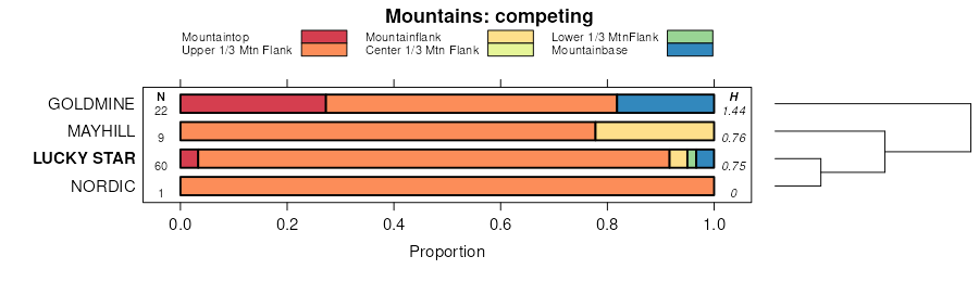
LUCKY STAR-SCOUT ASSOCIATION | LXE | 2468 | 482765 | j6c2 | ut603 | 1968 | 1:20000 |
LUCKY STAR-HOSKIN ASSOCIATION | LVE | 2251 | 482763 | j6c0 | ut603 | 1968 | 1:20000 |
CLUFF-LUCKY STAR ASSOCIATION | CHE | 1968 | 482686 | j68j | ut603 | 1968 | 1:20000 |
CURTIS CREEK-GORING ASSOCIATION,STEEP | CSG | 1687 | 482689 | j68m | ut603 | 1968 | 1:20000 |
LUCKY STAR-RED SPUR COMPLEX, 6 TO 30 PERCENT SLOPES | LWE | 1123 | 482764 | j6c1 | ut603 | 1968 | 1:20000 |
DESPAIN-LUCKY STAR ASSOCIATION | DSG | 814 | 482708 | j697 | ut603 | 1968 | 1:20000 |
MULT-LUCKY STAR ASSOCIATION | MSE | 668 | 482774 | j6cc | ut603 | 1968 | 1:20000 |
Lucky Star gravelly loam, 25 to 60 percent slopes | LDF | 10885 | 503871 | jx9x | ut604 | 1980 | 1:24000 |
Lucky Star gravelly loam, 8 to 25 percent slopes | LDD | 5500 | 503870 | jx9w | ut604 | 1980 | 1:24000 |
Lucky Star-Condie gravelly loams, 25 to 60 percent slopes | LEF | 1500 | 503872 | jx9y | ut604 | 1980 | 1:24000 |
Lucky Star silt loam, 30 to 60 percent slopes | LkG | 58075 | 506577 | k046 | ut609 | 1974 | 1:24000 |
Lucky Star-Charcol complex, 30 to 60 percent slopes | LmG | 30330 | 506578 | k047 | ut609 | 1974 | 1:24000 |
Lucky Star silt loam, 15 to 30 percent slopes | LkD | 4175 | 506576 | k045 | ut609 | 1974 | 1:24000 |
Lucky Star-Ercan association, very steep | LNG | 3640 | 506573 | k042 | ut609 | 1974 | 1:24000 |
Lucky Star gravelly loam, 40 to 60 percent slopes | LSG | 6026 | 482942 | j6js | ut612 | 1967 | 1:20000 |
Crandall-Lucky Star-Starley family complex, 30 to 70 percent slopes | 113 | 21187 | 508157 | k1s5 | ut613 | 1999 | 1:24000 |
Lucky Star gravelly loam, 30 to 60 percent slopes | 151 | 19264 | 508197 | k1tg | ut613 | 1999 | 1:24000 |
Lucky Star-Fewkes gravelly loams, 30 to 60 percent slopes | 153 | 10475 | 508194 | k1tc | ut613 | 1999 | 1:24000 |
Lucky Star-Dromedary gravelly loams, 30 to 70 percent slopes | 152 | 5862 | 508196 | k1tf | ut613 | 1999 | 1:24000 |
Crandall-Lucky Star gravelly loams, 5 to 30 percent slopes | 112 | 4965 | 508156 | k1s4 | ut613 | 1999 | 1:24000 |
Lucky Star gravelly loam, 15 to 30 percent slopes | 150 | 4804 | 508195 | k1td | ut613 | 1999 | 1:24000 |
Cuberant-Horsethief-Lucky Star families complex, 30 to 70 percent slopes | 711 | | 3312899 | 30gxf | ut645 | | 1:24000 |
Lucky Star-Skylick families complex, 30 to 60 percent slopes | 560 | | 3312884 | 30gwy | ut645 | | 1:24000 |
Lucky Star-Pritchett families complex, 20 to 60 percent slopes | 570 | | 3312892 | 30gx6 | ut645 | | 1:24000 |
Uinta-Horsethief-Lucky Star families complex, 15 to 50 percent slopes | 711A | | 3312900 | 30gxg | ut645 | | 1:24000 |
Lucky Star-Adel families complex, 30 to 60 percent slopes | 713 | | 3312901 | 30gxh | ut645 | | 1:24000 |
Croydon, moist-Lucky Star families complex, 25 to 60 percent slopes | 715A | | 3312903 | 30gxk | ut645 | | 1:24000 |
Lucky Star-Horsethief-Adel families complex, 30 to 60 percent slopes | 820 | | 3314871 | 30hm1 | ut645 | | 1:24000 |
Horsethief-Lucky Star-Cuberant families complex, 30 to 60 percent slopes | 81 | | 3314872 | 30hm2 | ut645 | | 1:24000 |
Lucky Star family, 5 to 30 percent slopes | 23B | 1193 | 3312846 | 30gvp | ut645 | | 1:24000 |
Lucky Star-Dagan, rubbly families association, 20 to 50 percent slopes | R20 | 10946 | 623876 | ny61 | ut647 | | 1:24000 |
Lucky Star-Hoskin-Roundy families association, 5 to 35 percent slopes | R2 | 9346 | 623878 | ny63 | ut647 | | 1:24000 |
Hoskin-Lucky Star families association, 25 to 70 percent slopes | R15 | 5884 | 623885 | ny6b | ut647 | | 1:24000 |
Lucky Star family, 30 to 60 percent slopes | R39 | 2346 | 623870 | ny5v | ut647 | | 1:24000 |
Elder Hollow-Gardners Fork-Lucky Star family association, 15 to 45 percent slopes | 52-68 | 1532 | 758271 | tg1c | ut647 | | 1:24000 |
Lucky Star family, 10 to 30 percent slopes | R27 | 1147 | 623880 | ny65 | ut647 | | 1:24000 |
Lucky Star family-Broad Canyon, very stony association, 10 to 45 percent slopes | 52-56 | 877 | 758311 | tg2n | ut647 | | 1:24000 |
Lucky Star family, dry, 25 to 45 percent slopes | 52 | 308 | 758309 | tg2l | ut647 | | 1:24000 |
Burnette-Lucky Star association | 10 | 15311 | 152053 | 536y | wy043 | 1976 | 1:24000 |
Mulgon-Lucky Star association | 48 | 5555 | 152093 | 5387 | wy043 | 1976 | 1:24000 |
Burnette-Lucky Star association | 10 | 1223 | 816471 | wdls | wy619 | 1971 | 1:24000 |

